Fix the antemeridian seam artifact #207
Comments
|
I haven't checked the shape files to see if the shapes are disjointed or not, but perhaps there's a possibility that the tool that was used to create the shapes was designed to apply strict ESPG:4326 constraints to the longitude and automatically split them. We need to be able to wrap around to solve the problem of continuity. |
|
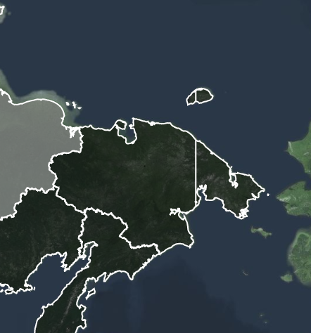
The 180th meridian seam is a known issue in standard cartography. The file in question is: https://github.com/codeforgermany/click_that_hood/blob/cceb9ea1/public/data/russia.geojson It's the polygon titled Using some jq wizardry to remove all of the other features in the geojson, leaving just Chukotka: The feature is of type Put this into geojson.io to see that the shape in question is simply broken into two pieces along the 180th meridian in the data file itself. |
|
Although the official recommendation from the RFC on the geojson format is to divide shapes so they don't cross the antimeridian to ensure general compatibility with software that works with geojson, in this particular use case it probably makes sense to consolidate the two pieces into one and let the longitude coordinate cross the meridian. My guess is the renderer should have no issue drawing it. |
|
I think it'd be nice to try to combine it and see what happens - but in my (admittedly not-very-smart-about-GIS-stuff), d3 deals with the antimeridian different than other packages - d3's approach is probably better, but I'm not smart enough to get it right. I had a heck of a time in #323 (and #330) getting all of the viewport calculations right AND keeping the antimeridian handling correct, and I'm not sure I got it always right. If you resize your window so it's too small with maps that push too far north, the distortion gets really, really bad. |
An issue for Russia and possibly Oceania and The World.
This should be one contiguous object:
The text was updated successfully, but these errors were encountered: